
The Archean Terranes of Minnesota (cont.)
2 Geologic Setting
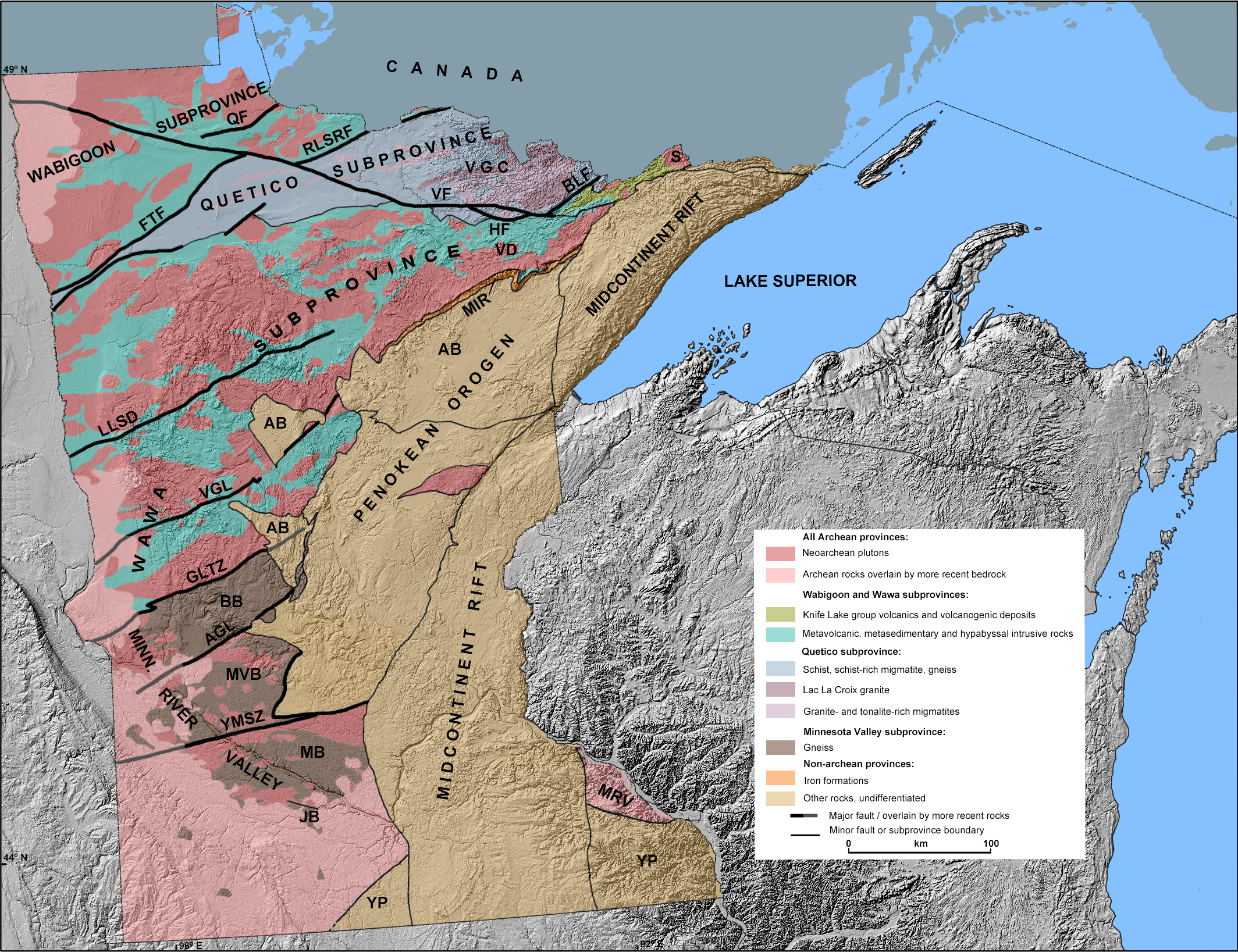
The North America craton, i.e. the ancient continent Laurentia, covers about half of Canada and of the conterminous United States. It was made up by the collage of several blocks of different ages, ranging from ~4Ga to ~1Ga. Its core is the Canadian Shield, itself formed around 2.7-2.5 Ga by the successive accretion of several micro-continents and the sedimentary basins that separated them. The Superior Province is its southwestern most province and is also the product of the reunion of several subprovinces. Four of them are present in Minnesota: from north to south, the Wabigoon, Quetico and Wawa and Minnesota River Valley subprovinces (fig. 2-1).
Click on the map to display the zoomable high-resolution map (2.7 MB). High-resolution map in PDF format (2.8 MB)
Figure 2-1. Geologic map of the Archean Terranes of Minnesota
AB-Animikie Basin, AGL-Appleton Geohysical Lineament, BB-Benson Block, BLF-Burntside Lake Fault, FTF-Fourtown Fault, GLTZ-Great Lakes Tectonic Zone, HF-Haley Fault, JB-Jeffers Block, LLSD-Leech Lake Structural Discontinuity, MIR-Mesabi Iron Range, MB-Morton Block, MVB-Montevideo Vlock, MRV-Minnesota River Valley Subprovince, QF-Quetico Fault, RLSFR-Rainy Lake-Seine River Fault, Saganaga Batholith, VD-Vermilion District, VF-Vermilion Fault, VGC-Vermilion Granitic Complex, VGL-Vining Geophysical Lineamebt, YMSZ-Yellow Medicine Shear Zone, YP-Yavapai Province. Sources: U.S. Geological Survey, Minnesota Geological Survey. Software: Quantum GIS (QGIS).
3 The Four Subprovinces
The Superior Province is commonly divided by into several subprovinces, each one corresponding to a former independent crustal unit. However it is common to use either the terms "province" or "subprovince" to designate a particular unit; the simpler term "province" is commonly used to designate any unit (e.g., the Minnesota River Valley Province"), while the more precise "subprovince" is mostly used to emphasize the subordinate character of a unit (e.g., the Wabigoon Subprovince is part of the Superior Province). In the same way, although technically different, the words "terrane" and "subprovince" are often used interchangeably.
The Wawa subprovince, i.e. the western half of the larger Wawa-Abitibi subprovince and the Wabigoon subprovinces are both typical Archean granite-greenstone terranes, composed of metamorphosed volcanic rocks (greenstones) later intruded by granitoids (e.g. the Giants Range batholith, south of the Vermilion fault). The Quetico subprovince is the former sedimentary basin lying between these two micro-continents and filled with their deposits (mostly turbidites). When the Wawa and Wabigoon accreted to each other, the Quetico area was compressed and deformed and its rocks metamorphosed into metasediments, also intruded by granitoids (e.g. Lac LaCroix granite). The Great Lakes Tectonic Zone marks the boundary between the Wawa subprovince and the older Minnesota River Valley terrane. The latter comprises four distinct regions, the Benson, Montevideo, Morton and Jeffers blocks, separated by faults and shear zones. They were first composed of ca. 3.5Ga gneisses (Montevideo gneiss, Morton gneiss), but were later intruded by granitoids (e.g. the Sacred Heart Granite) at ~2.5Ga. Later in the Proterozoic, the Penokean orogeny (~1.85Ga) then the aborted Mid-Continent Rift (~1.0 Ga) cut through the Wawa and Minnesota River Valley provinces. Parts of the latter remain in southeastern Minnesota, Wisconsin and upper Michigan.