
Lombard Thrust, Southwestern Montana (cont.)
2 Three Forks Area
In its southern part, the Lombard thrust is only visible in two areas: in the Hossfeldt Hills, north of Three Forks, and in unnamed hills, west of the same city, that we will call the Mulligan Canyon area, like Whisner et al. (2014). Elsewhere it's buried under Cenozoic sediments. Geologic studies have shown (e.g. Vuke et al. and references therein) that the folding and thrusting has affected not only the Paleozoic rocks visible at the surface, but also the middle Proterozoic rocks, belonging to the Belt Supergroup that lie under them, as in the northern section (preceding page). However, more to the west, the middle Proterozoic LaHood formation outcrops on the north (upper) side of the Jefferson Canyon fault. Like the Jefferson Canyon-Cave fault, the Lombard thrust is thought to result from a decollement between the Archean basement and the middle-Proterozoic basin-fill sediments of the Belt Supergroup (Whisner et al., 2014 and references therein).
2.1 Lombard Thrust in the Milligan Canyon area
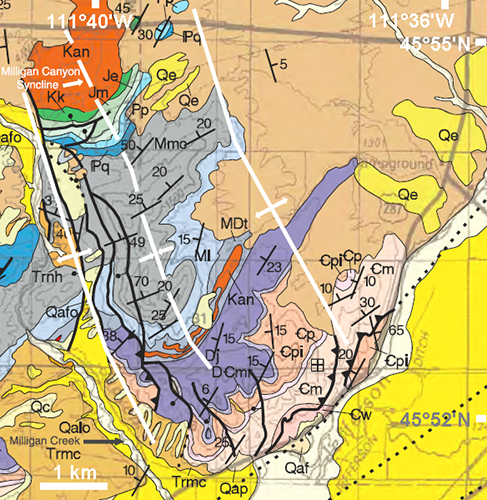
Figure 2-1. Geologic map of the Lombard thrust, in the Milligan Canyon area, west of Three Forks, Montana.
Syncline and anticlines in white. Selected units (explanation of the first letter given only once): _w: Cambrian Wolsey Shale; _m: Meagher Limestone; _pi: Pilgrim Limestone; Dj: Devonian Jefferson formation; MDt: Mississipian-Devonian Three Forks formation; Ml: Mississipian Lodgepole Limestone; Mmc: Mission Canyon Limestone; Je: Jurassic Ellis group; Jm: Morrison formation; Kk: Cretaceous Kootenai formation; Kan: Cretaceous andesite intrusion; Trca: Climbing Arrow member (Eocene) of the Bozeman group.
Base map: Bozeman 30x60 geologic map (Vuke et al., 2014; see the explanation of other symbols therein). Syncline and anticlines: Whisner et al. (2014).

Click on image to enlarge (2MB)
Figure 2-2. Panoramic view of the Milligan Canyon area.
Left view to the south-southwest. Center view to the southwest. Right view to the west-southwest. Harder beds are more erosion-resistant, hence the east-facing scarps. The cliffs on top of the scarps show the general westward dip of the layers. Note two Cretaceous andesite intrusions. The Three Forks basin, filled with Tertiary sediments, is in the foreground. Units with small outcrops or hidden by hills have been omitted. Dashed lines: approximate unit boundaries. Dotted lines with sawteeth: Lombard thrust branches (actual traces hidden by the hill in the foreground; the dots indicate their general direction; sawteeth on the overriding plates).
Units (explanation of the first letter given only once): _m: Cambrian Meagher Limestone; _pi: Pilgrim Limestone; Dj: Devonian Jefferson formation; MDt: Mississipian-Devonian Three Forks formation; Ml: Mississipian Lodgepole Limestone; Mmc: Mission Canyon Limestone; Je: Jurassic Ellis group; Jm: Morrison formation; Kk: Cretaceous Kootenai formation; Kan: Cretaceous andesite intrusion; Trca: Climbing Arrow member (Eocene) of the Bozeman group.
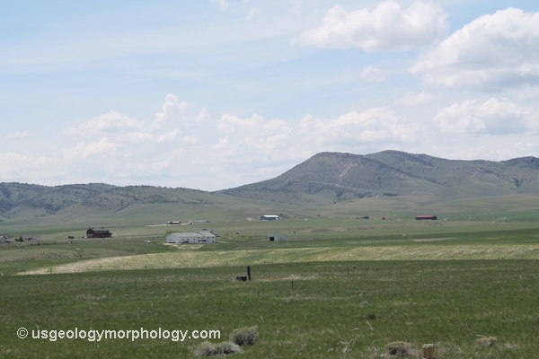
Figure 2-3. Close-up of the central part of the mosaic of fig. 2-2.
In the right (western) half of the photo, the resistant Mississippian Mission Canyon limestone (Mmc) forms the cliff above the Mississippian Lodgepole limestone.
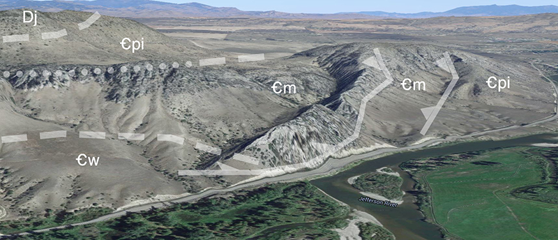
Figure 2-4. 3-D view from the south of the Lombard thrust, in the Milligan Canyon area, southwest of Three Forks.
Google Earth 3-D view of the south side of the left part of the panoramic view of fig. 2-2. Here, the Lombard thrust divides itself into two branches: the main one at right (east) and a short secondary branch at its left. Hard rocks (limestone, dolomite of the Jefferson formation) make steep cliffs, contrasting with the gentle hills in the Wolsey shale (foreground at left). Solid lines: thrusts (with sawteeth on the overriding plates). Dashed lines: unit boundaries (dotted when hidden by a hill). Units with small outcrops have been omitted. _w: Cambrian Wolsey Shale; _m: Meagher Limestone; _pi: Pilgrim Limestone; Dj: Devonian Jefferson formation. Google Earth image © Google. Google and the Google logo are registered trademarks of Google Inc., used with permission.
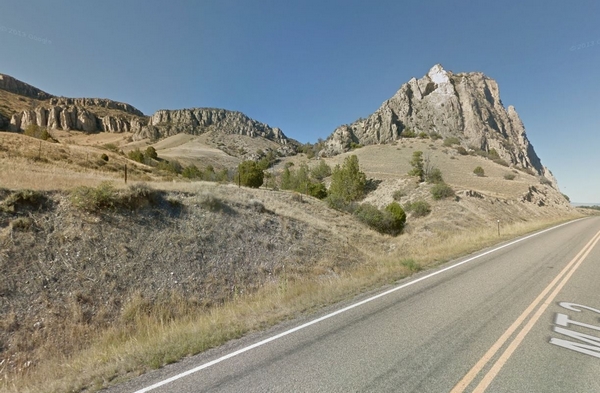
Figure 2-5. Western branch of the Lombard thrust in the Milligan Canyon area, southwest of Three Forks.
Google Street View from the south, along Highway 287. Note the cliffs carved in the Cambrian Meagher limestone (_m in the preceding figure). The foreground is in the softer Wolsey shale (_w). Google Street View image © Google. Google and the Google logo are registered trademarks of Google Inc., used with permission.